Day 62: rough start

Day 62
Miles: 18
Over Selden Pass to the perfect campsite

Can’t break the streak of late-starts. We had camped close by our friends Purple and Carnivore, early risers, and we hoped that they’d have a good influence on us… but we wake up to full sun and no sign of them. They must have snuck out of camp hours ago.

With all that sleeping in, surely hiking should be going better? We’ve only made two miles and I’m crashing hard. Today is not my day – either that or the Sierras are gradually, inexorably taking me down.

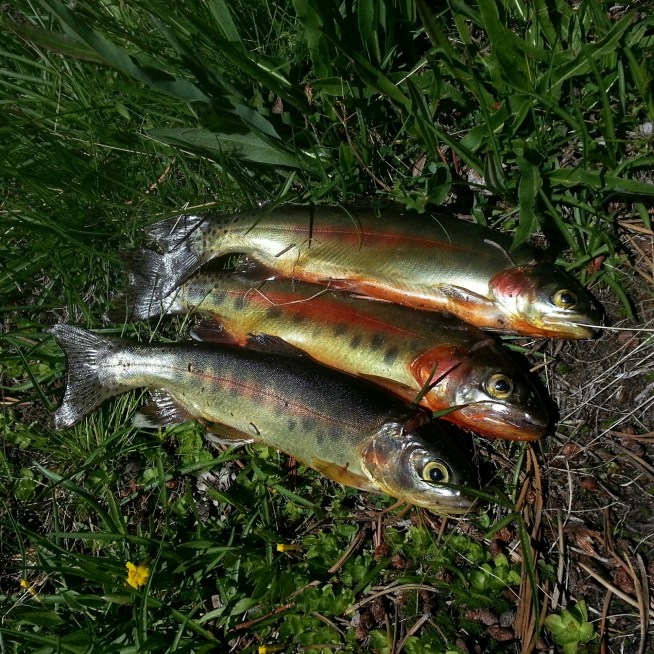
I collapse by a small, pretty lake. “Oh man,” says J. “Look at that lake. Look at those trout!”
  “Catch me some?”

Pop, pop, pop! Three trout, all in a row. J spends another half hour catching the last one, I clean them and put them in with foraged green onions. Food of the gods! “You’re never going to enjoy another trout dinner again,” declares J. What could compare with this? Maybe I can hike today after all.

image

image

Selden Pass goes easy. There’s a nice shear zone through the granite, the rock breaking off in thin plates. A cheeky ground squirrel sits by us on top of the pass, sharing the view (but not our snacks, too bad for him.)

image

Down, then up. The reliable down the pass, up the pass pattern is over. It’s a steep ridge, but the uphills always come through for us. Instead of pines, pines, pines, we’re in aspens. The undergrowth is flush with lupins and lilies.

image

image

(I know, this is a columbine, not a lily.)

Going up inexorably leads to going down. A little vitamin I eases the descent. We cross the bridge over Mono Creek and it’s getting late. I don’t think twenty miles are in our future, but perhaps?

image

image

More uphill, but the walking is hard. Rocky hard. Hunger cramps. No more gas.

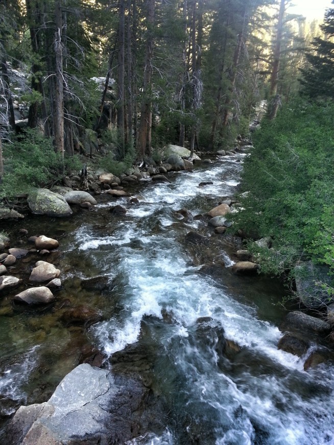
Then we see it – the perfect campsite. It’s across the creek, flowing downhill on a smooth granite chute, in a little grove of trees. “There it is,” I point out. Home. I roll a boulder into a narrow spot in the creek and we hop across. The tarp is an easy one tree pitch, then pasta sides and bed.

Share

Day 61: we do not pass

Day 61
Miles: 19
From evolution lake to a creek, before Selden Pass

Our morning matches our evening – leisurely. Once we start back up, our mini lake vacation is over. Well, sort of. We make it from one side of Evolution Lake to the other, then stop again. J needs to go swimming, and I need to re-braid my hair. It’s hard to believe we’ve finished all the major passes of the High Sierra. It’s a little sad.

image

Before starting this thru-hike, the places and things I was worried about were all a big anxiety stew. One place at a time, they’ve sorted themselves into places, days. The muddle gets strung like beads into a timeline I can’t reverse.

From Evolution Lake it’s a long ways down. We drop down fast, crashing down switchbacks and past JMT hikers as we try to make up time. First we follow evolution creek, then we ford it – the first time we’ve had to get our feet wet. “You know the drill, right?” asks J. “Three points of contact. Keep your hipbelt unbuckled. If you start getting swept off your feet, face upstream.”
  “Yup. Let’s do it.” Trail runners get swapped for camp shoes and in we go. Easy-peasy. The hardest part is not flailing at the mosquitoes, which somehow know that I’m totally vulnerable and descend in hordes.

image

image

image

Evolution Creek

Tasty, Storybook, and Crawfish are on the other side, eating lunch. We pass them by and follow Evolution Creek the rest of the way down. It cascades over a cliff, we switchback down. The San Joaquin River takes us down some more. We’re a long way out of high country already now, in tall pines, forested slopes.

image

image

image

We’re pounding out the miles today, but we pause at the trail head to Piute Canyon. “This is where I did field work on college,” J tells me, pointing up canyon. “Almost ten years ago now… that’s bizarre.” A couple hiking the JMT stops to chat, and tells us to be sure to check out the hot springs up ahead.

Hot springs! Don’t need to tell me twice!

Getting to Blayney hot springs involves a stream crossing a little bit more stressful than the first. Then a trek across a warm, squishy bog, lots more mosquitoes, and some wandering about. The hot spring is a turbid and murky pool with naked people in it. There’s an attractive couple from Santa Cruz, a John Muir lookalike, and -horrors- the annoying man from Muir Pass.

We take off our clothes and join them (when in California…), and proceed to have the exact same annoying conversation with the annoying man as the day before. It’s even worse the second time round. The couple from Santa Cruz leaves – I think it’s time we did as well. I was worried that the hot springs would blow up the rest of our day. Instead, I can’t wait to get out of here.

The mosquitoes chase us the rest of the way back to the trail, and fueled by annoyance and mosquito rage (I’ve got the rage!) I take us up the mountain. The vertical grade is completely unnecessary. Who planned this thing?

Nice thing about a stiff uphill – if you hike up long enough you will run out of energy to waste on things like being annoyed. I’m exhausted, but finally calm. We set up our tarp in the dark. Selden Pass tomorrow.

image

image

Share

Day 60: end of the fellowship

Day 60
Miles: 14
From just past grouse meadow to evolution lake
Muir Pass

We’re all hurting this morning, but Teal is in bad shape. “I just don’t think I should be in this much pain after taking four ibuprofen.”
  “Probably not, Teal.”
Teal decides to bail and get to a doctor. The quickest way out is over Bishop Pass, so he’ll take that. Bluesman is leaving us today too – he’s got to get off trail for some stuff at home, and if he doesn’t put on the rocket boosters his schedule won’t work. We misplaced our rocket boosters somewhere back in Arizona, so we’ll let him race ahead without us.

“I can’t believe we’re breaking the fellowship,” mourns Bluesman.
  “I know. Good times have to end eventually, I guess.” Thinking about hiking with just J and my own self for company feels a little bit lonely, and a little bit free. Our own fate is just on us now.

In the bright, late morning light, the canyon we slept in reveals itself as a twinned citadel of bright white stone, guarding its emerald meadows. This is King’s Canyon.

We see Teal off at the side trail for Bishop’s Pass; he leaves us with a bag of skittles to remember him by. Bluesman has dusted us already. I think about our friend Bob, hiking with the three Canadians. “I think the Canadians are ready for twenty-fives,” he’d told me. “J,” I say, “I think Bluesman was our Bob.”
  “Yeah,” he laughs. “And we were his Canadians!” We’ll have to see if we’ll be able to make miles still without our coach to drag us along.

King’s Canyon is spectacular, and gets prettier the higher we go. We stop when there is a man sitting right in the middle of the trail. J wants some snacks, so we end up embroiled in a conversation with the most annoying man I’ve ever met. After telling us that we are slow, behind, and running late, he gives us a barrel of unsolicited advice on how to do the rest of our hike. I take great pleasure in blasting past him on the switchbacks (although I end up panting for a long time after).

Heading to Muir Pass is the most beautiful stretch of trail I’ve ever been on. Cascades of water tumbling over stone fields, trails lined with flowers, sharp-edged peaks. Everything has such sharp lines here, such bright colors – blue, white, green, pink – you could cooler it in with a twelve set of crayolas.

We stop at Lake Helen, the bluest thing I’ve ever seen. A group of weekenders are admiring the view, and we chat a bit. “Why are you doing this hike?” asks one. J stops, thinks, then says slowly: “I don’t know. It’s a decision I made once, and I’ve just never reevaluated!”

“Oh no,” I think. “He’s going to reevaluate, then I’ll have to hike the rest of the way all by myself!”

He doesn’t though, and we hike to the pass together. We see Muir Hut, and the familiar sight of Bluesman’s back. “Bluesman!” we scream after him, and we reunite one more time before watching him disappear of the horizon.

We hang out in the Muir Hut while we decide our next move. J would like to do a section of the High Sierra Route, an alternate to the PCT pioneered by a climber. It sounds cool, if I wasn’t exhausted. The Sierras are amazing, but they’re wringing me dry. That, and the black clouds building behind us, and friends we’re supposed to meet in Tuolumne… We decide to stay on the main PCT and take a short day at Evolution Lake instead.

There’s a rock outcrop with a secret, sandy spot hidden behind it, and we set up our tarp. J fishes, I get swarmed by mosquitoes, and watch the water turn gold and lavender. We eat fish for dinner. No passes tomorrow.

image

image

image

Can you find the trail in the photo?

image

Tadpoles!

image

image

image

image

image

Lake Helen

image

image

image

image

image

Share

Day 59: long miles to Rivendell

Day. 59
Miles: 21
From lake Marjorie to past grouse meadow
Mather pass

We didn’t put up our net tent last night, and the mosquitoes finally chase us out of bed. The swarms are getting thicker every day.

We drop quickly below timberline for a lovely, morning, forest walk. We fall in with Tasty and Storybook at a stream crossing, all of us balancing on wet stones and logs to keep our feet dry. There actually hasn’t been a single stream I’ve had to wade through yet, although I hear we might have to do a real ford tomorrow.

The climb takes us up onto a plateau with broad shields of white granite, soft green grass, and bright pink flowers. J lies down on the springy turf next to a deep, murmuring stream. I sit next to him, under that immaculately blue sky, and run my fingers through his curls. I look at the mountains all around us and think: “what picture could ever capture this moment? This perfection?” I always try, but a smartphone camera is simply not up to a job this monumental. It can’t capture scope – or the happiness.

We’re getting close to the pass when we pass another group of hikers. One of them, an old, Japanese gentleman, asks, “you didn’t happen to see some sunglasses back there, did you?”
  “No,” replies J. “But I have an extra pair,” and he pulls out a spare pair of safety glasses and hands them over. We all introduce ourselves, and Kachun expresses his gratitude for his new glasses over and over – it’s really the least we could do – we hollered at him in his tent the night before after he’d gone to bed, thinking he was a different friend of ours. Besides, if you’re not going to be ultra-lightweight, you might as well be able to help people out.

Not much longer and we’ve hit the switchbacks. Once you hit the switchbacks the pass is almost over. We’d tried to guess which notch in the ridge was Mathet pass and J is wrong again, but Teal and Bluesman are waiting on top. The view is spectacular on the other side of the pass too. Fat marmots try to sneak up on our trail mix.

Going down takes us over slick, glacial polish to the Palisades lake. “J, we should go swimming.”
  “You want to?” he responds, surprised. I loathe cold water.
  “It’s to beautiful not to!” So we strip to our skivvies and jump in. (Ok, I actually get my feet wet, then have to spend another five minutes talking myself back into it. I eventually dunk myself.)

After the lake the trail unrolls into another amazing vista, then another. Narrow canyons with tumbles of rock and water, impossibly green grass, waterfalls, wildflowers, endless switchbacks down, down, down, down. Down, down. I’d be glad we aren’t going up, except that I’m pretty sure the next section of trail after this is a mirror image of this, heading up to Muir Pass.

We’ve come down into a smooth, U-shaped glacial valley, back below the timberline. The golden hour is upon us, and I’m exhausted, but Bluesman has a goal in mind and he’s dragging me, J, and Teal along with him. The white walls of the valley gleam in the fading light, and the white aspens are ghostly. We see the biggest Ponderosa pine that we’ve ever seen, and waterfalls, and giant, rushing creeks, then we’ve turned and start to climb again, up into King’s Canyon.

Grouse meadow is a green jewel in the gloaming. I’m exhausted, but Bluesman hasn’t stopped yet, so I keep stumbling on in the last dregs of the day. I’m so tired I don’t care about keeping up with friends anymore – I just want to stop! Unless I want to sleep on top of a boulder, that’s not an option though, and we finally stumble into Bluesman’s camp. Teal is not far behind, and even more destroyed – his Achilles tendon is giving him so much he can barely walk. We rush our camp set up, goaded by mosquito hordes. Sleep at last, to the sound of rushing water.

image

Don’t want to cross here…

image

J and Tasty find a good spot to cross.

image

Flower lined paths.

image

Heading up to Mather pass

image

More pink flowers

image

The two blues brothers – Teal and Bluesman, on top of Mather.

image

I see you Mr. Marmot.

image

image

I swear they hire landscapers for some sections.

image

Palisades lake

image

image

Another easy stream crossing

image

Rivendell?

image

image

Grouse meadow

Share

Day 58: a long uphill

Day 58
Miles: 15
From Rae Lakes to Lake Marjorie
Pinchot Pass

It’s raining on J. Cold, wet drips, as the frozen condensation inside our tarp melts, splash on his face. None of them hit me – I’m happy to stay in bed – but J feels otherwise. We can hear Teal hacking even though we can’t see him. He succumbed to temptation and smoked during his time in town, and he sounds like the Marlboro man, 30 years after the commercials. Guess it’s time to get up.

Bluesman takes off ahead, then Teal, with me and J bringing up the rear. We hike downhill a long ways, then turn into another valley and begin the long uphill to Pinchot Pass. Teal is under a tree, eating skittles. We throw down our packs and join him, and I put on my windshirt despite the warm sun. “I thought this was a windshirt,” I explain, “but it turns out it’s actually mosquito armor.”
“The mosquitoes can still bite you through that,” J chimes in.
“No they can’t.”
“Yes they can.”
“Well, they choose to never do so then.”
“That’s considerate of them,” J replies, irritatingly.

The mosquitoes have been sneaking up on us, absent sometimes, swarming others. It figures that someplace this amazing would have something wrong with it… a high-pitched whine in your ear and an itch you can’t scratch. I switched to wearing pants for the sun exposure, but now I’m doubly glad for the protection.

Starting up the uphill, I charge it. We run into our buddy Crush, getting water at a stream with two other ladies I don’t know. I had thought Crush was way ahead of us – he’s got legs like a seven-foot tall gazelle – but I think he gets hung up chatting with people. He’s always saying ridiculous things, preceded by the phrase, “as they say in Texas…”. His rationale for this is that there are enough people in Texas that no matter what he says, someone else there has probably said it at least once. The two ladies introduce themselves as “the girls.” They’ve just jumped on the trail a few days ago.
“Well, if you’re the girls, then one of you is left and one of you is right, right?” I ask them.
“I thought the same thing, but figured I didn’t know them well enough to say that,” Crush laughs. We pass on by and keep charging up the hill.

I’m exhausted. Why am I charging uphill? Why is this hill so big? “How far are we?” I ask J.
“Looks like about 4 miles to the pass still.”
“4 miles??” I throw my pack down and nearly have a meltdown, but I need to make a trip to the bushes more than I need to throw a tantrum. I’m sitting there with my pants around my ankles when I spot a lean, dun shape moving through the bushes nearby. “Mountain lion!” I think. “I’m going to get eaten with my pants down!” I hold perfectly still and watch, and the shape emerges again – with a sharp nose and bushy tail. Coyote. It’s a beauitful specimen, a bit thicker than the scrawny desert dogs I’m used to.

Four miles is long ways, but we walk it. We’re coming up on the pass – a long mountain ridge closing off the bowl we’re walking in. “Which spot do you think is the actual pass?” asks J.
“Mmm, I think it’s that low spot over there,” I reply, pointing to a dip in the ridge.
“I think it’s that one,” J says back, pointing to a different one. But I won the flip of the coin and we head to the right.

My favorite part of going over a pass is the moment just before you crest, when all you can see of the other side is bright blue sky, and there might be anything over there – lakes, castles, the waterfall over the edge of the world maybe. Then you crest, and it’s sharp ridges and mountain waters and Bluesman, waiting for us to share the view. We sit on top of everything and eat snacks.

Crush and the Girls are not far behind, and they stop for snacktime too. Another hiker, (who, inexplicably, has packed his pack so that his bear can dangles and smacks him in the butt every step he takes) makes the top as well. The Girls had assumed that their hiking partner was right behind them (he also, inexplicably, packs his bear can so it hits him in the butt) but it turns out that we’d all been mixing the two guys with giant packs up, and the dude hiking with the Girls is actually several miles behind, with altitude sickness. “Did you guys ever discuss what you would do if you got separated?” I ask them.
“Uh, no.” Soon, the conversation is all about plans of action, whether to go back, or leave a note, or ditch him because they don’t like him. I’m all involved until it suddenly dawns on me that this conversation is about attention, not solving the problem of a greenhorn hiker with too big of a pack and altitude sickness, and alone. I leave.

I left the conversation, but it keeps bothering me that there seemed to be no plan to go back and make sure this dude was ok. I don’t care how big of a prick someone is, it’s bad form to ditch them without even telling them about it.

We get to Lake Marjorie in the evening, just as the mosquitoes come out to swarm and the fish are out to bite. J takes his rod and catches us a whole mess of little brook trout that we steam with wild onions we’d found earlier in the day. After pasta sides and crackers and stale cookies and ramen, fresh trout tastes so real. The Girls show up, sans hiking partner. We go to bed late enough that we’ve outlasted the mosquitoes, and don’t set up the net-tent. Mather Pass tomorrow.

Share

Day 57: Double Duty

Day 57
Miles: 13
From Bishop (via Onion Valley Trailhead) to Rae Lakes
Kearsarge Pass and Glen Pass

An entire extra day of prep should have had us on the move with rocket boosters this morning… alas, procrastination begets more procrastination. Post office, packing, diner breakfasts, re-packing…I’m not sure we’ll ever get out of here.

At the post office, there’s a beautiful old GMC High Sierra. “High Sierra!” says J. “Cool logo,” he adds, and snaps a photo before he goes in. Tess and I are waiting out front when an older gentleman comes up to us, gets in my face, and accusatorily says, “What were you doing taking a photo of my truck!”
“uh, just the logo sir! We’re hiking the High Sierras, and you’re driving a High Sierra! Cool, right? ha ha?” The old man is not placated, but leaves us alone. I didn’t know I was so suspicious. Sheesh.

Packed to the gills with bacon and pancakes, no more chores left to delay us, Tess drives me, J, Bluesman, and Teal up to the trailhead to depart. It’s 1:30pm and we have two passes ahead of us. Our packs sink low on our hips with 8 days of food – the most we’ve ever carried – and we start up the thousands of feet of elevation leading up to Kearsarge Pass. I’m starting off right, with a trip and a stumble and flat on my face. “oof,” I mutter, from underneath my pack.

I bought new shoes in Bishop, and if this is any indication of how they’re going to treat me, things are not looking good. The gear store didn’t have the model of Salomons that I’d been wearing (the XR Mission), so I swapped in the XR Crossmax – it’s similar, but with a thicker foam sole, which seemed like a good idea yesterday. Problem is, the sole is also narrower, and I feel like I’m trying to hike in platforms. The shiny, pink kind. I roll my ankle again and again, cursing more every time.

Despite all that, it feels so good to be back on the trail. I’m starting to feel lost in the trail towns, like a fish in a suit. It’s not my place, and I’m overwhelmed by the stripmalls and food and people and internet. Walking is easy. One step one step one step. We charge up Kearsarge pass, finish the seven miles from the Onion Valley Trailhead, and finally re-join the PCT, leaving the desert and towns safely behind the mountains. I don’t want to see them, I just want the mountains, and the lakes, and the snowpack, and the wild. Forever.

Kearsarge Pass was a bit of a haul. Too bad it’s not our only pass of the day – Glen Pass awaits. My back-on-trail optimism takes a bit of a beating on the switchbacks, but I huff and puff to the top, where I find Bluesmand, surrounded by JMT hikers, where he regales them with PCT battle stories. Teal comes up right after J, and in the late afternoon we descend towards Rae Lakes in the Golden Hour. Bluesman drags us a few more miles and then we set up camp. Taking off my pack feels like getting out of prison, and we set up our tarp facing the Painted Lady Peak, it’s top still lit up like a Christmas Star for one more minute. The lakes are beaten silver, the trees black against darkening peaks, and words cannot do justice to this place. I’m exhausted. Pinchot Pass tomorrow.

20140627_164137_1[1]
Over Kearsarge pass, back in the promised land.

20140627_165215_1[1]
Bullfrog Lake

20140627_184738_1[1]
Coming up Glen Pass

20140627_191728_1[1]
Bluesman and Teal, heading down Glen Pass

20140627_192315_1[1]
Over Glen Pass

20140627_192730_1[1]
The golden hour…

20140627_194949_HDR_1[1]
J (aka Dirtnap) heading downhill

20140627_201011_1[1]
Last light on the Painted Lady

20140627_203239_1[1]
Twilight over Rae Lakes

Share

Day 55 & 56: Hot rest days

Day 55 & 56
Miles: zero
Bishop, CA

Took a rest day in Bishop – supplies and new shoes. I’m hoping with a new pair of shoes my feet won’t feel like they’ve been beaten with a hammer – at least not all the time. I sort of thought I’d have all the body issues worked out by now, but I’m beginning to realize that that’s not how the trail works. We looked outside this morning and changed our mind about heading out today, into heavy black clouds hanging over the pass. I’m ready to get out of town, but can’t muster the energy to break the trail-town vortex. It’s powerful. On the trail again tomorrow.

Share

Day 54: Over and Out

The sun rises right into my tarp – I squint an eye open at the fabulous dawn, then settle back into a content morning snooze. It’s going to be a town day anyhow.

We finally all get up and start the stiff hike up Kearsarge Pass. For some reason, I failed to connect the word ‘pass’ with ‘really steep climb up a mountain’. The trail is catching me up to speed on my vocabulary though – I’m huffing and puffing and about to bonk. J feeds me some snacks and we keep going. The grade on this section is ridiculous. The traffic on the trail is also something new too. Mt Whitney marked the start of the Pacific Crest Trail’s intersection with the John Muir Trail, and we pass dozens of JMT hikers, day hikers, section hikers, and weekend backpackers in a day. After having a trail all to ourselves for weeks now, it’s a bit of a shock. Especially since they are all going the other direction. 800 miles of looking at north pointing footprints, and suddenly they are all the wrong way. I feel like a lost salmon.

Up and over the pass, next to the incredible Kearsarge Lakes. The trail down to Onion Valley faces east to Owens Valley and the White mountains, down to dry country. It looks hot down there.

Motivated by visions of milkshakes and burgers, we burn the downhill miles. My hipbones are feeling especially abused these days, so I unbuckle my hipbelt and let my pack hang on my shoulders, where it feels about ten times heavier. For the first three days with my bear canister, I was packing it at the bottom of my pack. At the end of the third day, I only had to look at my pack to feel the implacable round case in the small of back, and putting on my pack had developed into a long, complicated process of layering extra clothes and dirty socks around my waist for some extra padding. It finally occurred to me to change how I was packing my pack, and my life instantly improved. I’m using the ULA Ohm 2.0, and it’s a tall, narrow pack, lightweight pack. It works great if you pack it right… For now, I pack my sleeping bag, sleeping pad, and net-tent in the bottom, using socks and gloves to fill in the gaps. The bear can slides in (upright) on top. Rainpants go between the can and my back, long johns fill in the sides, extraneous clothes squeeze in the cracks. So far, so good. It doesn’t collapse around the middle anymore; I no longer hate my life; I can get into my food without unpacking everything; it carries like a dream again. However, my hipbones are raw and deep purple from the first couple days, and they don’t seem to be recovering while I carry a pack on them for 10+ hours a day. Maybe a rest day will do the trick.

There are trail angels waiting with food at the Onion Valley trailhead – Uber-bitch and Bristlecone – far lovelier people than their names suggest. They feed us tortilla soup and grilled cheese sandwiches and give us a ride down to Independence. We emerge into a hot, dusty town – we’re an entire mile lower than we were this morning. Teal and Tess pull up to the Chevron and pick up Bluesman, Dirtnap, and me – trail friends, reunited again.

Share